Donnelly is a member of the American Institute of Certified Planners, and works out of Maryland in the United States. In December 2007 he was posted to Iraq as part of a Provincial Reconstruction Team (PRT) in Salahaddin province. He later worked with the United Nations Assistance Mission – Iraq (UNAMI) in their study of the disputed territories. As part of those jobs he looked into not only the current economic and political situation within the country, but traced back local governance in Iraq to the Ottoman Period. That led to extensive research, data collection, and the creation of some astonishing maps, some of which are included below. He provides unique insight into the creation of modern Iraq, the changes to its internal boundaries, the disputed areas of northern Iraq, what it means to govern the country, and the problems that posed for the United States.
Could you briefly explain what your work was in Iraq and what years you were there?
I served a special appointment to the US State Department as Senior Urban Planning Adviser as part of a Provincial Reconstruction Team (PRT) in Iraq from December 2007 through January 2009. In that position, I was initially assigned to Salahaddin PRT, Contingency Operation Base Speicher in Tikrit, Salahaddin, Iraq, which was part of the Multi-National Division-North (MND-North), then under Major General Mark Hertling of the 1st Armored Division.
In that capacity I was responsible for developing a systematic assessment of public services and infrastructure in order to assist Iraqi and US parties in synchronizing efforts, through governance, political and technical assistance, for rapid stabilization and post-conflict reconstruction. I was also responsible for implementation of civilian Geographic Information Systems (GIS). A civilian Geographic Information System (GIS) is a routine management tool where multi-source information is combined in a spatially linked environment: geo-physical, physical, population & service/facility distribution, administrative/political units, cadastral (property, ownership & tax) data, and land use/activities.
Myself and senior civilian transportation planning adviser Mouhsen Habib, P.E., (former Transportation Manager, City of Anaheim, CA) formed a planning cell based out of Salahaddin PRT. We were the only senior planning cell of its kind in Iraq, and, according to instructions prior to deployment, were responsible, where required, for providing civilian planning and engineering assistance throughout the MND-North area.
In September 2008, I was assigned by the U.S. Embassy in Baghdad to the U.N. Assistance Mission- Iraq’s (UNAMI) political team as planning, cartographic and demographic expert where I provided support for the UNAMI’s Disputed Internal Boundaries Team, together with experts in constitutional law, religion, minorities, elections, and humanitarian issues.
The focus of that work was documenting historical dispute factors, and providing analytical and advisory support for U.N. recommendations to Iraq for dispute resolutions generally related to Article 140 of the Iraqi constitution.
That research allowed the team’s constitutional documentarians to align the administrative decrees to create and alter provinces and districts with mapping and demographics, revealing a profound history of political/administrative boundaries since the Ottoman days.
And what do you do in civilian life?
In civilian life, I am a planning consultant/expert with 25 years of experience in development, infrastructure demand forecasting, regulations, demographics, and economics/capital budgeting with specialties in public services, schools, roads, utilities, budgeting, and Geographic Information Systems (GIS).
As part of your work you looked at Iraq’s provincial boundaries since the Ottoman period?
Yes.
I arrived in Tikrit in December 2007 with DVD’s full of available U.S. military and civilian mapping resources and technical reports, all containing embedded provincial political and administrative boundary information: which province and district is located where. All were anchored in 1992 U.S. National Imagery and Mapping Agency (NIMA) political/administrative boundary sources.
I spent the first month collecting information: traveling through the area, meeting provincial leaders and technical staff, identifying and assessing critical infrastructure and services, and, along the way, assembling local place, boundary/responsibility, and population data.
The more I traveled, and met with knowledgeable Iraqi provincial and ministerial officials, the more my list of mapping incongruities grew. In February 2008, for example, I traveled the southern boundary of Salahaddin, in and around Ad Dujail, a city notorious for Saddam’s 1982 vengeance after an attempted assassination (the Dujail Massacre). U.S. political/administrative boundary maps, however, showed Salahaddin continuing southward to include Taji, a district of Baghdad Province.
When I traveled north to Baiji, the U.S. maps showed Baiji’s district headquarters to be located in the Tikrit district, which made no sense.
When I traveled east to Tuz Kharmato across the Hamrin Mountains, they showed the Tuz District as including areas west of the Hamrin, which also made no sense.
The more I looked, the more anomalies I found. The difference between Baghdad City and Baghdad governorate, of which Taji is actually a district, is a constant source of confusion to U.S. mappers. When confused, they simply assigned Baghdad’s districts to the adjacent governorates of Salahaddin, Anbar, and Diyala.
One of the key disputed boundary districts is Dibis in Kirkuk Province. U.S. and U.N. maps incorrectly identified two adjacent districts as Dibis, incorrectly labeling Makhmour in Erbil as a second Dibis in Kirkuk.
All of these errors originated in the U.S. NIMA maps of 1992 and prior, which became the source for U.N. political/administrative mapping errors.
Some of the U.S. boundary errors were the geographic equivalent of erroneously assuming that Kansas City, Kansas, and Kansas City, Missouri are one in the same place. Some were much more complex and pervasive, where different brigade level maps and mapping data provided conflicting district maps. Thus, if you compared the Division’s district maps to the local battalion’s, they could not be reconciled.
Compounding all of this was, as I learned from our U.N. research, was the reality that the political/administrative boundaries since Ottoman days were the governmental equivalent of a never-ending game of musical chairs as districts and sub-districts were continuously arranged and rearranged within and between governorates.
The game was so well-known to Iraqis that when the Government of Iraq’s Kirkuk Committee was first seated in October 2008, their first question was: “Which Kirkuk are we supposed to study?”
What kinds of difficulties did all the internal boundary issues pose for your work and others?
Very few U.S. parties understood the significance of this issue.
It is against this context, well known to Iraqis but not to U.S. parties, that U.S. efforts to “build” provincial governance capacity tied to distribution of inaccurate boundary maps, were continually frustrated.
Since 2003, the U.S. had divided their efforts into various “battle spaces” (divisions, brigades, battalions, etc.) and U.S. civilian administrative areas (PRT areas, USAID and NGO activity centers, etc.), and was, in early 2008, attempting to build Iraqi capacity for self-governance.
On paper, PRTs were assigned by province, but typically worked directly with U.S. brigades, and were transportation/security constrained to just the provincial capital. Salahaddin, however, was divided into three brigade spaces, one anchored at Contingency Operation Base Speicher in Tikrit and associated with Salahaddin province’s capitol, and the others associated with Ninewa and Kirkuk.
To expand the Salahaddin PRT’s reach, Team Leader Steven Buckler began establishing and staffing local PRT “satellites” at Baiji, Balad and Tuz Kharmato, each of which began working with district-level officials to create improved provincial linkages.
Much of my civilian planning work relates to complex political and administrative boundaries, service area mapping and forecasting (schools, utilities, etc.), and property rights and property tax matters. The PRT roll out in 2007 allowed, for the first time, specialists like myself to join the effort at the ground level.
It is critical for a reader to understand that whether under Ottoman or Western/U.S. political/administrative systems, or in Iraq, political/administrative boundaries are directly linked to property (cadastral) records for tax purposes, voting, service planning and allocation, etc.
Political/administrative boundaries are, therefore, directly tied to actual properties and property boundaries, which, in turn, are directly tied to, for example, voting rights and population counts (used in the U.S., Iraq, etc., to allocate federal resources down to lower units (provinces/states and below).
Changing a political/administrative boundary is, necessarily, a complex, formal and technically grounded action involving the movement of specific properties, and their residents, from one tax collector, government service chain, and voting district to another.
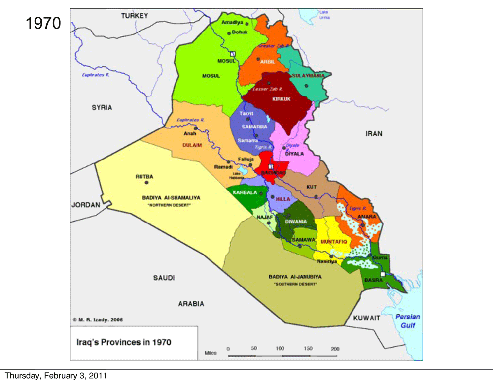
You provided me with some of the map work that you did. How many provinces were there in Iraq in 1958 and what were their names?
There were 14 governorates and three desert territories (unsettled places) in 1958.
The governorates were: Mosul (including modern Dohuk), Irbil, Kirkuk (from north of the Lesser Zab River to the Diyala River and including Chamchamal), Sulaymaniya (not including Chamchamal), Baghdad (including Tikrit and Samarra), Dulaim, Diyala, Karbala, Hillah, Kut, Diwaniya, Muntafiq, Amarah, and Basra, which were formally administered as provinces.
The desert territories included the Jazira Desert, Northern Desert and Southern Desert, and were administered as tribal territories.
 |
| (M.R. Izady) Click on for larger image |
The 1970 governorate count was 17: Mosul, Irbil, Kirkuk, Sulaymaniya, Salahaddin, Baghdad, Dulaim, Diyala, Karbala, Najaf, Hillah, Kut, Diwaniya, Samawa, Muntafiq, Amarah, and Basra.
The Northern and Southern Desert Territories were continued with Basra gaining some of the Southern Desert Area.
The significant changes in the 1970’s were:
(1) The creation of Salahaddin from Baghdad, with the Jazira Desert Territory carved up between Dulaim, Mosul and Salahaddin
(2) Creating Najaf as a province carved from Karbala
(3) Dividing Samawa out of Diwaniya
Inter-governorate boundary changes also affected: Hillah/Dulaim, Kut/Amarah, and Muntafiq/Basra.
 |
| (M.R. Izady) Click on for larger image |
The governorate count for the 1990’s was 18: Dohuk, Mosul, Irbil, Tamim, Salahaddin, Sulaymaniya, Anbar, Baghdad, Diyala, Karbala, Babil, Wasit, Najaf, Qadisiyah, Dhi Qar, Maysan, Muthanna, and Basra.
The significant changes in the 1990’s were:
(1) The creation of Dohuk
(2) Dissection of Kirkuk (now Tamim) among Salahaddin, Sulaymaniya, Diyala and Irbil; (Chamchamal was split between Salahaddin and Sulaymaniya)
(3) Creation of Muthanna from Samawa and the Southern Desert Territory
(4) Reforming Dulaim (now Anbar), Karbala and Najaf to include parts of the Desert Territories
(5) Renaming Kut (now Wasit), Hillah (now Babil), Diwaniya (now Qadisiyah), Muntafiq (now Dhi Qar), and Amarah (now Maysan)
(6) There were no more Desert Territories after the 1990s.
Additional intergovernorate boundary changes also occurred.
 |
| (M.R. Izady) Click on for larger image |
There were 18: Anbar, Babil, Baghdad, Basra, Dhi Qar, Diyala, Dohuk, Irbil, Karbala, Maysan, Muthanna, Najaf, Ninewa, Qadisiyah, Salahaddin, Sulaymaniya, Tamim, Wasit
Between 1990 and 2003, the major changes were:
(1) Reconstruction of Mosul (now Ninewa), adding areas from Dohuk, and losing areas to Tamim and Salahaddin (al Shirqat/Assur)
(2) Deconstruction of Karbala, reducing its size and authority to an area similar to Baghdad province; areas reassigned to Anbar and Babil. Karbala’s historical connection to the religious travel corridor (the “Haj Trail”) between Qom and Mecca was severed
(3) Expanding Anbar (at Karbala’s expense)
(4) Reconstructing Tamim to include districts transferred from Salahaddin and Mosul (Ninewa)
(5) Reassigning Chamchamal District to Sulaymaniya (from Tamim and Salahaddin)
(6) Minor inter-governorate boundary changes between Diyala and Wasit.
 |
| (M.R. Izady) Click on for larger image |
It is often said that Iraq is a “made-up” country, the accidental result of the Treaty of Versailles, where the Ottoman Empire was carved up into protectorates and “Nations.”
This myth, with accompanying imagery of British adviser Gertrude Bell and Winston Churchill dividing up the Middle East during an English Garden party (before jumping down Alice’s rabbit hole for further entertainment), is incorrect and misleading.
The general political and administrative boundaries of modern Iraq conform with well-understood historical and physical boundaries with three exceptions: Kuwait, the waterways south of Basra, and the undefined desert regions: Kuwait, once part of the Ottoman Basra province, emerged as a separate “nation” under British tutelage; the desert boundaries, with few permanent inhabitants, remains a somewhat ill-defined place (despite paper demarcations); and, the waterways were further defined by much later treaties between adjacent Iran, but the “Thalweg,” the center line of the waterways, continues to naturally shift against Iraq’s interests.
With few exceptions (Kuwait and minor Iraq/Iran border areas), the settled Iraqi population has known where Iraq was, including Kurds (who were very aware of which part was Iraqi, Iranian and Turkish Kurdistan), on a generational basis, and those boundaries remain unchanged.
Moreover, local people know their local area, from township and below: who they pay taxes to, which markets their goods are exchanged in, who to see for government matters. The Ottomans and all their successors maintained intensive and well-documented local property ownership/control and taxation systems, together with clearly established local governance systems. Even if services were minimal in nature, or ineffective, local systems were well known.
What is “made-up,” changeable, and as confusing to Iraqis as to anyone else, is the internal sub-national political/administrative structure: what district is my town associated with, and which province is it, in turn, associated with?
Instead of thinking of Iraq as a modern creation then, you believe that the country had its origins in the Ottoman Empire and its administration?
The Ottoman Empire gradually established control in the vacuum of destruction left by the Mongols. Ottoman control waxed, waned and had many expressions in the course of revolutions, reforms and the ebb and flow of imperial interest in the now decimated and unsettled Iraqi areas.
The historical tradition of a governorate or province descends from the Ottoman administrative unit of a "villayet," literally the place where the sultan's flag flew. This was, in turn, divided into districts (qaddas, qasas), and, further into sub-districts (nahias), equally an extension, and subservient unit, of the sultan. Ottoman administration, at the local administrative level, represented a complex weighing of interests between military, administrative, religious (millets providing sharia law), and local representation through notable elders. This is remarkably different from a US state's association, through compacts, to form a Union to which certain powers were, by agreement and consent of its people, delegated upward.
During the majority of the Ottoman Period, Iraq, like most Arab areas under their dominion, were troublesome and unsettled areas---far-off “colonies” primarily useful as sporadic tax revenue sources when the costs of administration/control did not outweigh the taxes collected.
During the late 1900’s, Ottoman rulers, struggling to save their failing empire, instituted various administrative reforms (Tanzimat) in the Arab areas, including Iraq. Many of the reforms, inconsistently administered through appointed military/civilian leadership, were too little, too late.
Ottoman appointees to these troublesome areas were typically successful military leaders, deriving their incomes from the local areas under their control, and that background was appropriate to these assignments, and reflected in the organizational structures created.
One Ottoman reform was to better organize the governorates, districts and sub-districts to map and align the size of the smaller units with the control/revenue/income relationship to the local Ottoman administrators, and, in turn, to the higher district and provincial system.
Unlike the almost random NIMA boundaries of 1992 (many of which were bezigons, or computerized straight lines extending for miles in the wrong direction), the Ottoman districts, like most logical boundaries anywhere in the world, followed the subtle and shifting geographic definitions created by rivers, hills, and local road and settlement patterns.
Other Ottoman changes consisted of major regional projects initiated by the Ottoman Court, limited by sporadic funding, to improve Court tax revenues from these areas: building roads and railroads, and reconstructing canals, that follow the same pattern as recent U.S. “nation-building” efforts.
Gertrude Bell’s field reports from Iraq make very interesting reading if you are able to follow both the geography and role and structure of the recently abandoned Ottoman administrative apparatus she was surveying.
In more recent times, what were some of the major causes for all the internal boundary changes within Iraq?
The purpose and impact of many of the pre-1970’s changes was on community and cultural leaders, but driven by logical administrative changes as Iraq’s core population shifted from rural to more intense non-rural populations.
After the 1970’s, the majority of changes were national/provincial power plays, reshaping political/administrative boundaries to punish some and reward others by Saddam.
Arguably, Saddam’s focus on renaming provinces harkening back to ancient history (Qadisiyah, Salahaddin), had dual purposes: to promote Saddam, by promoting historical evocations of Iraq’s past importance.
Building up Salahaddin, with Tikrit as its capital, was a matter of personal aggrandizement, as well as dividing threats and populations (removing Ad Dujail from Baghdad and placing it under his “thumb” in Salahaddin); and, placing Samarra under Tikrit (and not Baghdad) had widespread religious/ethnic significance, too.
Destruction of the Marsh Arabs’ habitat and diminution of Shiite areas was, for the most part, retributional, as was the reconstruction of Tamim as a heavily government controlled “Industrial Zone.”
These boundary changes went hand-in-hand with many other actions, including demolition of towns and mass exterminations (Halabja was just one example). Turkmen populations in Kirkuk, for example, saw their homes demolished and the land confiscated in the center of the historic town. Ninewa residents lost their homes and land to Saddam, who distributed it as part of an officer’s “perks,” harkening back to old Ottoman practices. “New Towns” in Ninewa meant mass resettlements to virtual concentration camps scattered throughout the Mosul plain.
Thus, drilling down below the governorate and district changes, there were many levels in play.
A Province Transformed: Ninewa From 1952-2010
Ninewa - 1952
 |
| (Stephen Donnelly - Notations) Click on for larger image |
Dohuk Created As A Separate Province
 |
| (Stephen Donnelly Notations) Click on for larger image |
Shirqat District Transferred To Salahaddin
 |
| (Stephen Donnelly - Notations) Click on for larger image |
Baaj, Hatre, Makmour Added
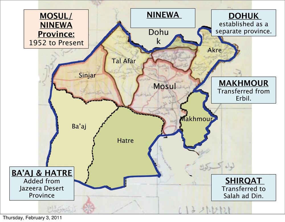 |
| (Stephen Donnelly - Notations) Click on for larger image |
Modern Ninewa
 |
| (Stephen Donnelly - Notations) Click on for larger image
One of your observations then is that real governance in Iraq is based upon the district levels, which largely have long historical roots?
|
The daily experience of government in the United States, outside the door, is local. Local streets with potholes to be fixed, garbage to be picked up, traffic signals and controls to be managed and enforced, etc. But the U.S. system of governance is not national at all. It is a system of more than 50 independent states, each of which is further distributed down to counties, districts, cities, towns, etc. The decisions as to major project and service priorities are, under most reasonable circumstances, made based on local priorities carefully managed through economic choices within a sustainable and locally supported tax base. Behind the scenes is a continual process of gamesmanship for state and federal resources, weighed against disputed demands for “strings” such as mandates and conditions (the carrots-and-sticks), and between one locality and another. Further in the background for most residents are the many regional compacts, special purpose government structures, and inter-governmental service agreements that assure, for example, regionalized water management, a metropolitan transit system, and emergency responses to outlying areas.
Not a year passes that a state’s top court does not have before it a case involving disputes between local and state government, or between one type or level of local government with another. Nor does a year pass in which the U.S. Supreme Court is not asked to define, or redefine the limits of national and state powers and responsibilities. The result is an ever-changing definition and mix of decisions, actions, services, taxes, and intergovernmental redefinition between nation, state and localities.
This messy and very real-life process, in a nutshell, encapsulates the complexity of actual government/people/services relationships needed to answer the question: What is government?
It is that messy question of real-life governance that goes to the heart of U.S. efforts at “nation-building,” executed haphazardly through an almost Stalinist and unrealistic approach to top-down national dictates, and implemented through “projects” that were, in many instances, locally unsustainable, and, in many instances, precluded the appropriate evolution of sub-national governance systems
Iraq, from an internal administrative and governance standpoint, is a “World Turned Upside Down” at least twice during the lifespan of the average Iraqi adult. Once during Saddam’s Era, and again as we stumbled to dictate a new government from the Green Zone based on substantial input from Iraqi exiles living abroad for years before hand.
The noted historian, Phebe Marr (“Modern History of Iraq”), explained in 2003 that Iraq’s pre-occupation with foreign intervention precluded necessary attention to internal administration.
Arguably, Iraq’s geography, often the battle line between cultures, resources and economics, creates a permanent need for external attention, but the attention gap on internal administration, like Egypt today, remains an unfinished critical task with many dimensions, opportunities and risks.
Could you give some examples of how this system all works or doesn’t work within Iraq?
In January 2010, hydroelectric power generation operations were shut down at the Mosul Dam since water flows fell below the levels needed to drive the turbines.
Also in January 2010, Kirkuk’s provincial authorities effectively disconnected its power plants from the national grid.
Iraq’s national power grid is a distributed linear system carrying power from far-flung regional plants in Mosul, Kirkuk, Sammara, etc, to power-hungry Baghdad.
Every drop of water not falling from the heavens, not effectively bought or bartered from upstream neighbors, or lost due to internal mismanagement attributable to a lack of effective regional and local water management strategies and programs, is a bucket full of Iraq’s national lifeblood unnecessarily spilled on the desertified clay on the plains of the Land Between Two Rivers.
In a desert country, water is life. In Iraq, the effective management of water is power, food security, national wealth, and prosperity.
Nothing done by the U.S. in the last eight years, for example, has resolved the critical risks to Iraq’s future posed by the lack of water management agreements in the headlands of the Tigris and Euphrates, thus the need for an outward national focus.
At the same time, however, Iraq’s lack of any effective regional, provincial, and local water management strategies and programs, the essential other side of the coin, magnify the damaging effects of declining external water flows, and underscore the significance of internal administration gaps.
Solutions such as trading increased water flows from Turkey and Syria for Iraq’s present life blood, its oil, are always possible, but without strong internal water management strategies and programs, any such resources bought at a high price to Iraq’s oil inheritance will be substantially squandered.
Certainly, Saddam’s external relations were catastrophic, but the real and perceived external threats that made this dictator possible still exist, and nothing done by us between 2003 and today has created any substantive external changes, such as an effective international compact on regional water management.
The state of internal politics and administration as of 2003 was untenable, regardless of Bremer’s choices regarding the existing government. Keeping the existing internal system was, in many ways, no better a choice than creating a new one from scratch.
What was needed in 2003 in order to fend off the chaos that followed was a truly deep and broad transitional administrative role, recognizing that Iraq’s economy, infrastructure, and administrative structure was in chaos, and the task, upon occupation, was far more complex than the two-pronged “nation-building” strategy of national constitution and projects, guided, or misguided, by a handful of Iraqi exiles, and Baghdad-based political/social/cultural elites.
What the transitional administrative role should have been is first, to establish stability, second, to repair basic infrastructure and services, and third, to look to the past and the future, and engage responsible regional and local parties in an informed process of creating transitional structures and processes providing for an evolution of internal administrative structures, recognizing that a final system, to be developed by Iraqis overtime, would, inevitably, be complex, somewhat unstable, and potentially conflict-ridden.
Given the U.S’s early focus on rapid turn-over, its ambivalence to “occupation,” and the lack of adequate planning, strategy and resources, what was produced by the end of 2008 is, perhaps, the best that could have been expected, and, inevitably, led to our “no strings” and “no lasting benefits” departure.
What remains, still, for the Iraqis, is to develop a functional and effective internal government and administrative structure.
If I could rub the genie’s lamp for a wish that could produce an improved and lasting relationship between the U.S and Iraq, it would be for the U.S. to focus, for Iraq’s benefit, its diplomatic and technical resources on bringing attention and support for a regional water compact, and to provide technical assistance for Iraqis in developing internal water management strategies.
These two areas, external and internal water resource management, are, in fact, the twin lions at the gates of Iraq’s future stability and prosperity.
Beginning in 2008 the U.N. began looking at 15 disputed territories in northern Iraq, and you were involved in that work. Those were Sinjar, Tal Afar, Tilkaif, Shakihan, Aqri, Hamdaniya, Kirkuk, Dibis, Daquq, Hawija, Tuz Khormatu, Kifri, Khanaqin districts, and the Mandali sub district. What specifically did you do as part of that U.N. team, and what were some of your major findings?
Attached is a map showing those subject districts and sub-districts (Mandali) that were the focus of U.N. investigation for formal review and recommendations.
 |
| (Stephen Donnelly - UNAMI) Click on for larger image |
Behind those map lines are the integrated data on populations, infrastructure, economic assets, oil reserves, energy facilities and distribution systems, and all the other key factors needed to conduct a reasonable analysis of many of the DIBS questions.
Obviously, if there is a dispute about boundaries and districts, accurate definitions of the district lines and organizational systems, and the allocations of factors across and within them are essential.
Once these lines were established, it was then possible to coordinate many of the other studies being conducted by the U.N. DIBS team, including documentation of the administrative decrees which changed the boundaries, and identification and documentation of specific conflict patterns (village eradications, “new towns,” mass killings, forced resettlements, etc…) to the specific places and populations in dispute.
If a resolution is to be historically based, some definitive history must be reduced to geography and people in order to complete credible discussions.
One essential line, which many of the U.N. team members worked on was the so-called “Green Line” which marked the boundary with the Kurdistan Regional Government (KRG), providing KRG control over those areas under their administrative control as of March 19, 2003.
While this provision looks definitive in the Transitional Administration Law (TAL), Iraq’s interim constitution created by the Coalition Provisional Authority, the fact is that it was never geographically defined, creating a continual uncertainty as to the “base line” for any discussions to change boundaries.
Although never completely defined, the team, through interviews on the ground, and U.S. military assistance, was able to much better defined the “Green Line” after we completed our work in 2008.
That better-defined line set in theoretical stone in the TAL, however, disagreed in many respects with the commonly accepted lines recognized by many Iraqi and U.S. parties from 2003 to 2008.
It would be wonderful to suggest that a U.N. Study Group could solve all the problems in a complex environment, but that is unrealistic.
In fact, from my first-hand experience, much of UNAMI’s successes in this area came not from formal reports but, in the way of most politics, by quiet one-on-one negotiations.
Such was the case with minority set-asides in provincial elections, which resulted, in large part, from effective diplomacy by Staffan de Mistura, UNAMI’s Special Representative for the U.N. Secretary General, who, together with the U.N. Political Team assisted all the parties to define and adopt appropriate solutions.
As that example demonstrates, the important contributions of UNAMI’s DIBS efforts were, to a great extent, more the result of process and diplomacy, and not in any particular report or explicit action.
As a U.S. civilian with no prior experience with the U.N., I quickly came to understand that the most valuable contributions of UNAMI’s DIBS team, while focused around a report and recommendations, was actually in the Iraqi dialogues fostered, and the potentially bad things that did not occur.
My role as the mapmaker, along with the U.N. Team and the many Iraqi and U.S. parties assisting us, was to bring more clarity, as part of a facilitated conflict-resolution process.
Could you go through what the U.N.’s general recommendations were for those disputed areas?
No. Sorry, but they were not released publicly.
The U.N.’s mandate was to facilitate discussions and decision-making by the appropriate parties, across a fairly broad spectrum, to include, for example, “neighbor” issues (Iran, Turkey, Syria, etc.), minority issues (ethnic, religious, etc.), sources and history of conflict, things that unite and things that divide, and proposed courses for future dialogue and non-violent dispute resolution.
In that context, the Political Section for the DIBS work was staffed with various international experts with specialties in international and constitutional law, Article 140, history, religion, minority issues, voting rights, economics, demographics, cartography, and regional specialists. The effort was headed by Peter Bartu, a USC professor with substantial experience in conflict-resolution (East Timor, etc.).
The DIBS Team conducted broad-spectrum investigations, including extensive fieldwork and interviews at every level. It also established and maintained relationships with all of the “neighbor” countries, and senior Iraqi leadership.
It was not unsurprising in a critical team meeting for one member to explain the discussions held with Iran’s president the day before, another the meeting with the Grand Ayatollah this morning, and another with a meeting last week with an obscure minority representative in a northern district---all being synthesized to better understand a matter presently before the Iraqi Parliament.
Notably, the parties involved in the conflict-resolution process are personally knowledgeable about the matters in dispute, having spent, in many cases, a lifetime with them. Unlike U.S. annual “rotations,” many of the U.N.’s team have been involved in Iraq since 1998, so the scope of their knowledge and contacts was substantially broader than many U.S. “experts.”
The complex history of any particular matter in Iraq defies easy answers of “good guys” and “bad guys” since many parties, with the exception of some minorities, were, at best, wearing beige or slightly grey hats (no white hats).
Necessarily, the burden on the DIBS Team was, initially, to complete documentation, followed by a balanced presentation, laying out issues and options to frame and facilitate dialogue. This in a context where Iraq’s interest and capabilities for self-governance was growing daily.
Across this mandate, and with all the perspectives gathered and provided, there was neither a “magic bullet,” nor a “Grand Plan.” Instead, there was a process of information sharing, preliminary recommendations (heavily documented and caveated) to parties who were personally knowledgeable about many of the matters under review.
Several of the team have published works, Gareth Stansfield (University of Exeter) and Sean Kane of the United States Institute of Peace (USIP) for example, that embed, in their individual viewpoints, much of what the team covered, but the U.N.’s reports were offered in confidence, and remain so.
Gareth Stansfield’s book provides a fairly exhaustive history and background of the Kirkuk and Kurdish issues, which he has spent years documenting.
Sean Kane’s most recent works through USIP reports and a joint Brookings Report (“Kirkuk as a Special Governorate”; “Unfinished Business”) conveys the scope of considerations about the complex and intertwined relationship between Iraqi national politics, Article 140, and the maneuvers surrounding the proposed Oil Law.
As he accurately describes, there are reasons why U.S. and the international community’s interests and motivations in moving forward to formally resolve Article 140 and the Oil Law were not commonly held by Iraqi parties, for a variety of sound internal reasons.
He also points out that Article 123’s provisions under the permanent constitution open the door to options including Kirkuk as a Special District, with or without association with KRG.
Bear in mind that Article 123 of the permanent Iraqi Constitution, hammered out in 2008, provides for special provinces and alternative regions, provinces and areas which, in many ways, is viewed by certain parties to have displaced substantial elements of Article 140 in the Interim Constitution.
Thus, the “clear mandate” implied by Article 140 of 2005 was, by 2008, much less clear, and even more so after the 2009 Provincial Elections where voting patterns in Kirkuk were, at best, a draw between Kurdish and non-Kurdish voters.
In May 2009, the U.N. handed over their report to the central and regional government in Kurdistan. What were their responses?
The U.N.’s recommendations were provided to senior Iraqi and Kurdish parties as part of a process of establishing and supporting frameworks for Iraqi dialogues.
The U.N. mandate, by some international readings (Article 140), was to go far beyond this advisory and facilitation role, however, by late 2008 and early 2009, going beyond would have conflicted with the state of emerging Iraqi self-determination.
The Iraqi parties have the reports, and many of the district and sub-district level studies, so they are available as part of a process, which is complex, and on going.
Do you think the U.S. was behind the U.N.’s suggestions or not and why?
No, the U.S. was not a major part of the U.N. DIBS process, except to provide support and expertise to the team.
To be clear, I ended up on that assignment in September 2008 with the ominous assurance from senior military and embassy officials that Kirkuk and the disputed boundaries were the most important remaining task for stability in Iraq. So, there was no delusion about the importance of my assignment to the U.N. DIBS team.
At the same time, the U.S. was very “hands off” and collegial about mine and the team’s work, assisting where they could, and getting up-dates or adding important information they had gathered. Nothing “cloak-and-dagger” at all.
On several occasions, I officially briefed senior U.S. parties, mostly to: (1) keep them up to date; and (2) look for more input, support. For my part, it was more on the “out of sight, out of mind” theory that I maintained regular contact (plus, they had to sign my pay records every two weeks).
The U.N.’s movement and basic intelligence (mapping, air photo capabilities, etc…) capabilities were very limited, so the U.S. provided a lot of support for U.N. field teams, and an open door to civilian team interface.
I’m aware of the 2009 Wikileaks cables (from newspaper accounts) directing State Department staff to spy on the U.N. staff. No such thing ever happened during my watch---quite the opposite.
On one occasion in 2008, a senior U.S. diplomat (a new “rotational” arrival) was sent to my office, a separate office within the Team’s unit and festooned with maps, sheepishly looking for a map of the “Green Line” or “Kirkuk.” He was obviously concerned that the “U.N.” folks (like me?) might be reluctant to part with it. I handed him a CD containing the same maps and power points I had used to brief another U.S. diplomat the day before and he left with the apparent excitement of having scored a major coup. I don’t think he noticed that my ID Badge was the same as his: “U.S. State Department.” Nor that there were two U.S. direct employees on the team, and several U.N. staff members of American citizenship and residence.
For some period, while the SOFA was being negotiated and afterwards, I believe that a lot of U.S. parties thought they had a great deal more control than they did. So, there was no need to uniquely engage either the U.N. or Iraqis except through U.S. channels.
Bear in mind, too, that the Green Zone was a very small world for the diplomats involved in these matters. You could share the coffee line in the morning with Meg Sullivan, there to assist with SOFA negotiations, have dinner with the senior U.S. diplomat working on Kirkuk matters, and take some U.S. colleagues to the U.N. Compound (the “U.N.-Bar”) in the evening to play Foozball along with British friends. The separation of all these folks was never as great as it might seem from the outside.
After 2003, the U.S. was so officially focused on the trappings of nation (constitution, stock market, etc.) that little attention was paid to the structure of nation. The TAL simply reinstated Saddam-Era local laws and systems as previously enacted, and without regard for the fact that much of those later enactments were both evidence of and causes of conflict.
In hindsight, I would have preferred a rollback to pre-Saddam sub-national status quo as a starting point in 2003. But….
In fact, in my opinion, the U.S. never really understood these sub-national issues, and never substantially contributed to their analysis or resolution, or influenced any actual or conceptual solutions.
By late 2008 and early 2009, when the U.N. reports and recommendations were finalized, the U.S.’s influence and engagement on the KRG/Green Line/Kirkuk issues was minimal, but they (and especially the Ambassador) knew that the better approach was to be very “hands off” while the U.N. facilitated Iraqi’s paths to their own solutions.
On the Kurdish side, there were plans to redraw some of the boundaries in the north, like returning districts to Tamim that were broken off by Saddam to neighboring provinces. What would be some of the repercussions of such an action if it was ever implemented?
On the Kurdish side, there was a clear mandate (Article 140, TAL, 2005) to resolve boundaries by census, and, later, political commitments through Maliki, to implement Article 140 on schedule.
Article 140 provides for phases of implementation beginning with (1) normalization to be completed on March 29, 2007; (2) a census completed by July 31, 2007; and (3) a referendum to be completed by November 15, 2007.
Normalization involves repatriation of Kirkuk’s prior districts and sub-districts. Normalization also involves either actual or election-based population segregation/repatriation for the many Arabs resettled into the area in prior decades.
The formal national census has been delayed many times, but the maps and training were long ago completed, and the Census Bureau’s provincial and regional branches produce routine quarterly and annual updates (which are pretty accurate). KRG’s branch operates independent of, but under guidance of Iraq’s bureau.
Absent normalization and the census, defining areas for referendum is a tail wagging the dog.
The repercussions of these Article 140 criteria, agreed at the national level during a very unstable period, are substantial on real people, and create major portents for Iraq’s future.
These substantial repercussions are, of course, the reason that stalemate was the final agreed action, thus punting the issue to a possible future Article 123 solution that is, in all likelihood, less defined and less definitive.
Overall, what is your general opinion of the future for the disputed territories?
The disputed boundaries have been disputed for centuries, and many of the historical reasons continue.
If you start an analysis with the Ottoman Period, the result will be different from using Iraqi Independence from Britain, the Baathist Period or the U.S. 2003 Invasion.
The populations in these areas, and the areas themselves, have changed many times, and, at a given point, many different parties can articulate legitimate claims to the same piece of real estate.
As for Kirkuk’s disposition, the recent provincial elections were a draw between the Arab-associated Iraqiya (38%) and the Kurdistan Alliance (37%), suggesting no clear path, and with substantial minority concerns (Turkmen) arguing for a Special District for Kirkuk, pursuant to Article 123. Overall Kurdish-allied parties, on a combined basis, were just under 50% of combined votes cast.
My general opinion is that a 51% vote is probably not enough to create a definitive resolution to so substantial an issue. Given the closeness of the 2009 Kirkuk voting patterns, relying on a 51% vote raises substantial risks versus, say, a supermajority (60%?), which might be more definitive.
The same minimal majority framework exists, to a greater or lesser degree, in all the disputed areas.
As oil comes to the fore, the pressure for geographic, operational and administrative stability increases, as does the pressure for oil-related provinces, regions and special districts to capture more of the benefits and revenues generated.
Based on Iraq’s history, and the varying populations, cultures, scale efficiencies, challenges faced, and economic geography, the final result will not conform to simple textbook models, and will, overtime, be carved and shaped by a punctuated evolution sometimes driven by conflict and bloodshed.
Lines drawn and redrawn in blood are not inconsistent with Iraq’s history.
It will be complicated for a long time, and that is OK, and not unexpected.


14 comments:
Thanks so much for an excellent write-up. I was deployed to Salhuddin province in 2008 and 2009 stationed at Joint Base Balad. I keep in contact with one of my interpreters from Iraq. I hope that the country will evolve into a democratic type state where sometime I could take my family on vacation! Thanks again for the interesting article.
MAJ Chris Emmons
Arizona National Guard
Very enlightening. Thanks for posting this.
Congratulations on such an informative interview.
Joel, have you read Hanna Batutu's "The Old Social Classes and the Revolutionary Movements of Iraq" billed as a Study of Iraq's Old Landed and Commerical Classes and of its Communists, Ba'athists and Free Officers ? It is a dense academic tome, but unexpectedly extremely readable if one is an iraq junkie. Read somewhere (Non Arab Arab I think)that one can't hope to understand Iraq unless you have read this book. Which am proud to say I have!
There's one thing that perplexes me: Stephen says:
"As for Kirkuk’s disposition, the recent provincial elections were a draw between the Arab-associated Iraqiya (38%) and the Kurdistan Alliance (37%), suggesting no clear path, and with substantial minority concerns (Turkmen) arguing for a Special District for Kirkuk, pursuant to Article 123. Overall Kurdish-allied parties, on a combined basis, were just under 50% of combined votes cast.
My general opinion is that a 51% vote is probably not enough to create a definitive resolution to so substantial an issue. Given the closeness of the 2009 Kirkuk voting patterns, relying on a 51% vote raises substantial risks versus, say, a supermajority (60%?), which might be more definitive."
Unless my memory misleads me, Kirkuk was not given the opportunity to vote in the 09 provincial elections at all? In fact you recorded that here. So to which elections is Stephen referring?
Once again my congrats and Stephen too, for his important work over there. It would have been nice tho, if he'd been able to tell you wot the UN had recommended. What a scoop for you that would have been. Wikileaks, eat your heart out!
bb,
Stephen was referring to the 2010, not 2009 elections, for the results in Tamim.
Also, the full 09 UNAMI report's findings have not been released, but their proposals for Kirkuk have been talked about in several articles. Their proposals for that area were to: 1) Adding more details to the steps to follow under Article 140, 2) Changing constitution to make Tamim a regular province, 3) Split authority over Tamim between Baghdad and Irbil, 4) Giving special status to Tamim
great interview. THANKS. I hope Mr Emmons will be writing up all his recollections about his time in Iraq, assuming he hasn't already done so. It would be really invaluable.
Great post, Joel. It's too bad Stephen Connelly wasn't hired to run the CPA.
bb,
Thanks for the heads up on the book. ("The Old Social Classes and the Revolutionary Movements of Iraq") I'm reading a lengthy review of the book now.
www.dissentmagazine.org/democratiya/article.php?article=64
Unfortunately, at over 1,200 pages I have no time to read that while I'm working. I have literally dozens of old reports on the Iraq war that I haven't even gotten through yet. It's really tough juggling grading papers for work, reading and writing about Iraq, not to mention family. Perhaps during the summer I'll have the time to order a copy and get through some of it.
Joel, everyone:
I want to thank you all for the well-considered responses. My guess is that, even with maps and formal decrees in hand, many of which are disputed by the facts on the ground, they only provide, at best, 90% of the story. Only the Iraqis can set forth a complete picture.
bb's reference to the Hatatu books is on point, but relates in many ways to others maps and studies, particularly the land ownership, agricultural and industrial patterns which we also mapped out in separate studies.
Balad, for example, contains a Canning Factory, and used to hold the very large cattle spread, breeding stations, slaughterhouses, etc... that traced to one of those old land owning families (which also controls Iraq's largest private bank). In interviews with farmers about pre-2003 practices, it is clear that they operated in the same "value-chain" integrated basis as, for example, Purdue Chicken, which provides farmers with chicks, feed, oversight, purchasing, financing and marketing.
Several farmers (which may or may not be representative) expressed positive interests in re-establishing that old system, as well as respect for the families. It is possible that, long after Hatatu, as oil money flooded the economy and urban flight placed an increased importance on the farmers, that the terms of trade within that system were markedly different than "feudalism," as in older days.
Most important, though, many of these systems, the great holdings, and the infrastructure that supported it was all heavily damaged, stripped, looted, etc... It will be interesting to see, in the future, how the issues addressed by Hatatu in early days will play out in Iraq's future.
As one nod to history, the Planning Minister, Dr. Baban, is from an old Sulimaniya family which was among the last Kurdish leaders to settle with the Ottomans during the 1880s. Of course, his position today derives not from lineage (alone), but from considerable professional education, years of experience, and deft politics (no doubt).
But even the Kurds, today, evidence distinctions with, for example, the Barzanis (the landed families), the Talibanis, urban technocrats, and the newer minority parties. The future will be interesting.
I came across this article (http://www.ninanews.com/english/News_Details.asp?ar95_VQ=FGFDEG) citing illegal land trading practices in Kirkuk lately. In light of what Mr. Donnelly says about the boundaries of provinces being linked to property
It is critical for a reader to understand that whether under Ottoman or Western/U.S. political/administrative systems, or in Iraq, political/administrative boundaries are directly linked to property (cadastral) records for tax purposes, voting, service planning and allocation, etc.
Political/administrative boundaries are, therefore, directly tied to actual properties and property boundaries, which, in turn, are directly tied to, for example, voting rights and population counts (used in the U.S., Iraq, etc., to allocate federal resources down to lower units (provinces/states and below).
Changing a political/administrative boundary is, necessarily, a complex, formal and technically grounded action involving the movement of specific properties, and their residents, from one tax collector, government service chain, and voting district to another.
I wonder if the Kurds are implementing this as a tactic to tip the Kirkuk situation in their favor.
NJH sorry it took so long to get back to you. I recently had some health issues and couldn't write or type.
As for the article, you cited, it doesn't say anything about who was behind the illegal land sales other than some land brokers. That could just be some crooked businessmen.
There are a ton of current land disputes in Tamim province stemming from Saddam's Arabization program. There was a committee set up in 2004 to deal with the cases, but it has been overburdened and slow.
Unfortunately, most of the information and musing in this interview/article on Iraqi internal subdivisions are lifted from my work. The maps, as someone has identified them by a caption underneath them, are clearly mine and listed as such. What is not listed, is the accompanying texts of those maps which form the very essence of this interview with S. Connely.
Any one can click on the link to my work at Columbia University, see those provincial maps of Iraq, and read the accompanying texts to note where the material for information of the Mr. Connelly who is being interviewed here come from. He of course makes no mention of my work or me as the source. Sad indeed.
Below is the link:
http://gulf2000.columbia.edu/maps.shtml
And the text accompanying one of maps read as follow. Please read and compare to what is being provided in this interview:
""Gerrymandering has been one of the more common features of the Iraqi provincial boundaries. For various political and ethnic expedients, Iraqi provinces have been carved up over and over again, most recently, after the Iran-Iraq War (1980-1988). In this instance, the Shi’a dominated province of Karbala was nearly wiped off the map in favor of the Sunni dominate province of Anbar, which now encompasses nearly a third of the entire landmass of Iraq. Likewise, the Kurdish provinces in the north were carved up and large chunks of them were incorporated into Sunni dominated neighboring provinces.
This has had an unintended and amusing impact on the recent Iraqi elections: Only the Anbar province could muster the two-thirds majority needed to reject the new Iraqi Constitution. Provinces of Mosul (enlarged and renamed Ninawa), Samarra (enlarged and renamed Salahaddin) had too many non-Sunni Arab territories and peoples added to them by Saddam to be able to muster a veto vote. Three provinces with two-thirds majority were needed to reject the Constitution; only Anbar managed that. As such, the Constitution passed over the objections of an overwhelming majority of the Sunni Arabs.
The historic names of many provinces have also been changed—sometimes comically--to suit the Sunni political and historic vendettas. Thus Kirkuk became T'amim ("Socialism"), Diwania became Qadisiyyah (after the 7th century battle of the same name between the Muslim Arabs and the Persian Imperial troops that opened up Iraq to Arab settlement and Islamic influence that Arabized and Islamicized the country )""
Mr. Izady, Stephen Donnelly and I had a long running email exchange, which led to this interview. Part of it was on the history of Iraq's borders going back to the Ottoman times and beyond up to the present. I specifically asked him about the more recent changes. Your maps were used because they are the best publicly available and your name is placed under each to give you credit as the source. The questions for that part of the interview were then based upon the years for your maps, and Donnelly explained the changes that occurred in each.
If you read the rest of the interview you will note that part of it tries to cover how these boundaries came about dating back to ancient time, and the other half is about Donnelly's experience on the ground in Iraq working for the Salahaddin PRT and later UNAMI with Iraq's disputed territories.
So overall, while one section of the interview used your maps as the basis for questions, I don't think the piece is lifting your work, and you are duly noted as the source for each one of the maps that were used.
This is a response from Stephen Donnelly.
Joel:
Mr. Izady's cartographic work and maps provide a really good and colorful snapshot of various changes in Iraq's provincial structures, which, I assume, is why you used them as supporting illustrations for the interview.
I frequently refer to these widely circulated provincial maps (with copyrights indicated) as a great tool to illustrate the scope of many administrative changes relevant to understanding Iraq's recent past, and future.
Coming from the public administration arena, where political/administrative maps change frequently (census reapportionments, school attendance boundary changes, city annexations of adjacent suburban areas, special taxing district boundaries, etc...), my perspectives and research bases are, perhaps, different from those of Mr. Izady's.
Obviously, Mr. Izady did not have access to all the relevant historical source data (census tract boundaries, field notes, administrative decrees, and tax parcel data) we had available in 2008, nor to the level and quality of more recent geo-synchronized physical base data.
Thus, he did an incredible job, as a cartographer using c. 1992 NIMA map base data, in those Iraqi provincial snapshots given that lack of detailed source materials, and contemporaneous geo-synchronized data.
Unfortunately, some of the incongruities discussed in the interview, such as reducing Baghdad's size to the city only (not the Amenate), are corrected in the attached UNAMI map, as described in the interview.
Many more Iraq mapping inconsistencies derive from the lack of high-quality survey datum in prior years. The 1957 Iraqi census is often called the first "real" census because it employed maps derived from a credible British mapping survey, but that survey no longer stands up to satellite-based standards, and attempts to reduce these map lines to actual ground features demonstrates continuing problems.
For the UNAMI maps and project, my approach was to build the provincial lines from the constituent district lines and underlying census tracts and areas, using historical government tax/planning maps. These were then reconciled through ArcGIS with modern geo-synchronized data sets made available to Iraq's Ministry of Planning in 2008.
In a recent USIP publication, former UNAMI team member Sean Davis has published a list of sequential administrative decrees altering boundaries in some of the disputed areas.
He provides a USIP "composite" illustration of some of our district-level detailed work, directly traceable to the administrative decrees and more recent mapping source data.
Even in Sean's 2011 description and "composite" maps, there remain many provincial/district-level areas of genuine jurisdictional disputes and/or confusions (Makmuhr, Acre, etc...) which can only be officially resolved by Iraqis.
The same patterns of dynamic administrative changes (and continuing discrepancies) evident in Iraq exist in many places in the world, driven by either political, economic or social instability/change (Libya, Afghanistan, Pakistan, etc...), or, as with the US---western expansion, suburbanization or the impact of railroads and/or interstates in reshaping political landscapes and, thus, relevant and contemporaneous geography.
continued:
"Gerrymandering" is a pretty loaded term for what, in many instances, are logical, but significant changes in political and administrative geography, which occur with frequency in the US and elsewhere. Whether they are evidence of conflict, cause of conflict, or resolution of conflict is a fact-specific determination resulting from detailed analysis of the changes, the reason for those changes, and their results on people and places.
In the geography profession, there is a clear distinction between the general cartographic representation of an area (for general use as Mr. Izady has done), and the accuracy and integrity of a political/administrative/cadastral map, which must drill down to actual properties and geographic features, and be officially established to be relevant.
In my professional view, the use of static maps to illustrate dynamic circumstances, especially fluid ones in conflict, is the equivalent of using a wind-up pocket watch, and fraught with the risk of becoming a driver of conflict.
In Iraq, I was frequently presented with various versions of Mr. Izady's Green Line maps, the integrity and sources of which were not verifiable, and which were frequently presented by disputing parties of "proofs" of something or another. Thus, my reluctance to draw such lines in my work in lieu of simply showing others (including Mr. Izady's) as a framework for analysis, and reaching back for historical and documented mapping sources.
Mr. Izady's cartographic sequences of provincial maps do an excellent job of illustrating the professional problems with static maps: effective political/administrative geography, for conflict-mapping purposes, requires dynamic mapping, documented, and time-sensitive, and reducible to actual ground features.
Even where lines threaten to be drawn in blood, they should, at the least, be accurate and documentable.
Post a Comment